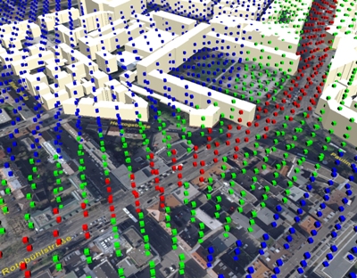
Researchers at the Fraunhofer Institute for Building Physics IBP and the Fraunhofer Institute for Industrial Engineering IAO have developed a three-dimensional planning tool (a three-dimensional map) for urban planners.
 Fraunhofer Institute for Industrial Engineering IAO
The researchers were part of the “Virtual Cityscape” project. Parametric modeling is another tool developed as part of this project. Traffic volumes, fine particulate matter and noise levels affect the people living in cities. Urban planners use simulation models for determining the ways to protect the nerves and ears of inhabitants from noise, and also to determine the best ways for building new airports and highways. The data used for the models is received in the form of two-dimensional survey maps and they do not contain any spatial data.
The new tool provides a three-dimensional view and enables urban planners to move, virtually, through the city. The noise data is simulated in the form of green, yellow or red boxes. This data floats at their corresponding locations. The map can be displayed in the form of a bird’s-eye view, street level zooming or a specific point. The three-dimensional map can help identify problem locations.
The researchers used the tool and found that electric cars also created significant noise, equivalent to that produced by gas-driven cars. While starting up, the electric cars had a very low noise level, but at speeds of more than 30 km/hr they emitted significant rolling noises. These simulations are being presented at the Hannover Messe in April, 2007.
The parametric modeling tool enables easy modification of structures. Feeding in new dimensions changes the structure appropriately. It considers the usage and logistics flows and includes them in the planning.
Source: http://www.fraunhofer.de/